Kununurra began in 1961 because of the Ord River development. Arriving there on 4 August,we had no intention of exploring the area, feeling that we had seen the best in 2008. We looked for a caravan park with SHADE and a grassy or concrete site. The big parks could not give us what we wanted so we ended up close to the shopping centre at Town Caravan Park, where we had shade, a large site, friendly people and clean amenities.
By 4pm we were walking in the local national park, Mirima, and were pleasantly surprised by the numerous trails, interesting rock formations and flora.
 |
| Beehive formations seen from above |
|
 |
| Acacia richardii |
 |
| White-quilled rock pigeon |
Next morning we were picked up
to go on the
Lake Argyle Kimberley Cat cruise, having done the Ord River cruise in 2008. The driver
and captain both did their best to make the experience memorable, but we found it rather boring, with nothing of natural history interest. The 2008 cruise was much more interesting because the captain dwelt on the fate of farms which we could clearly see and there were some birds.
 |
| The comfortable vessel |
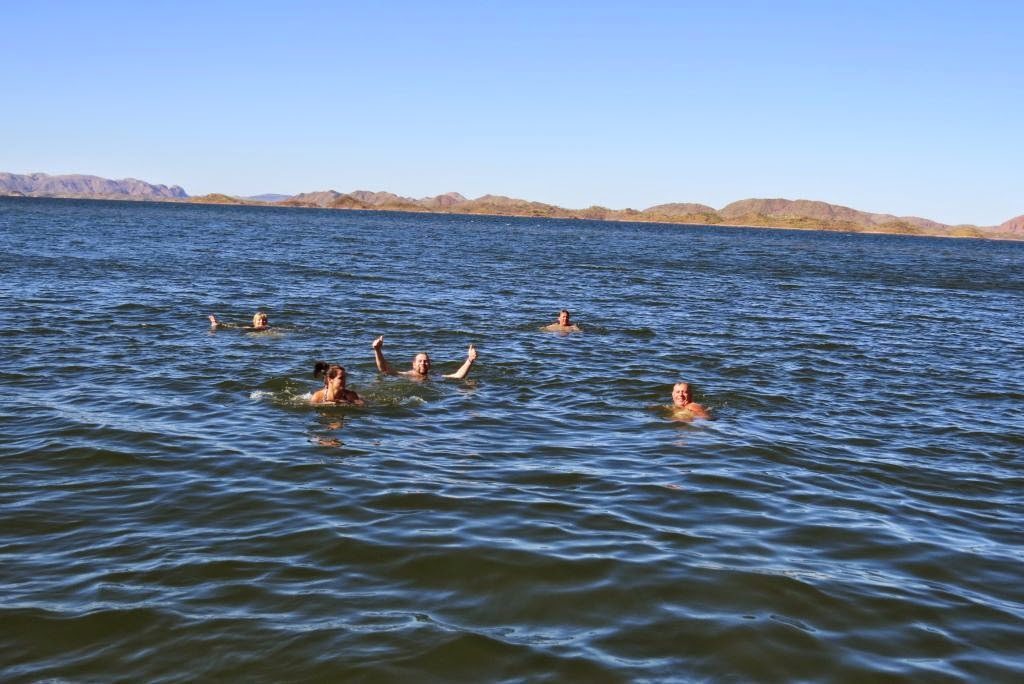 |
| Highlight for some was a dip in the lake |
 |
| The view |
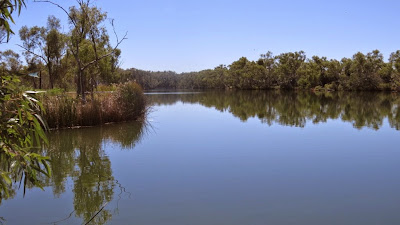
We spent the next day looking for birds at various sites with some success and arrived at Ivanhoe Crossing around 6pm, where some fisherfolk and cormorants were trying their luck.

 |
| Dragon tree flower Sesbania formosa |
And so on to Purnululu (Bungles), driving 200km of sealed road to the caravan park established
at the turn-off on the adjoining property, Mabel Downs.
In 2008 we left our trailer in a rest area and used a pup tent for an overnight stay.
We decided to stay 2 nights to get maximum time in the national park, 53km drive away on an unsealed road. The weather was very hot and, as we
started to set up camp on a dry, sunlit powered site, we noticed a
lovely green, shady unpowered site opposite. They let us change our
booking but no refund for no power. It was a good move as we were very
comfortable in the shade.
 We saw many birds just next to our site, including this black-faced woodswallow, plus red-backed wrens, great bower birds, white-winged trillers, mistletoe birds, finches, honeyeaters, kites ...
Leaving at 6:30am, we arrived at the Vistor Centre after 8 easy creek crossings and 90 minutes driving.
Our first walk was to Cathedral Gorge where our stay was enlivened by the singing of 2 young girls. I spoke to their parents about the wonderful acoustics and asked if the girls would like to sing. Then a couple in their 60s with drone camera came, asking our permission to send up the drone as it makes a loud buzzing noise. So up it went, getting views of the gorge from above. Technology!
We saw many birds just next to our site, including this black-faced woodswallow, plus red-backed wrens, great bower birds, white-winged trillers, mistletoe birds, finches, honeyeaters, kites ...
Leaving at 6:30am, we arrived at the Vistor Centre after 8 easy creek crossings and 90 minutes driving.
Our first walk was to Cathedral Gorge where our stay was enlivened by the singing of 2 young girls. I spoke to their parents about the wonderful acoustics and asked if the girls would like to sing. Then a couple in their 60s with drone camera came, asking our permission to send up the drone as it makes a loud buzzing noise. So up it went, getting views of the gorge from above. Technology!
Taking a different route back to the car, we passed typical beehive formations and many termite dwellings, including the tallest 'mound' seen.


The walk to Echidna Chasm was pretty but tiring, very hot and stony ground.
The chasm is reached through some very narrow paths and is quite small.
 |
| Senna venusta at Echidna car park |
 |
| Grevillea byrnesii - our daughter is Suzy Byrnes |
Our last walk was a short one to Bloodwood lookout where the main interest to us was the bloodwood trees.
Fitzroy Crossing was our next stop and we intended to drive north from there to the Gibb River Road and onto Bell Gorge. However, our 3-month old gas regulator stopped working which left us with no way of cooking in non-powered situations (open fires are usually banned). So instead, we drove west and then north to Derby, where a kind bloke came on a Sunday and replaced the regulator for $150 (which we eventually retrieved from Cub). Undaunted, we decided to drive east on the Gibb River Road to reach our chosen destination (we had been to Windjana and Emma Gorges on our earlier trip).
 |
| Boab in leaf |
By midday we
passed the turnoff to Windjana and soon came to Napier Range with Queen
Victoria’s head rock.
At 12:15 the sign
for King Leopold Range appeared, 140km from Derby turnoff.
We entered King L Park at Boundary Creek,
elevation 280m.
Some bad corrugations
and found a grader working (elev 430m), which gave us hope that our return
journey would be better.
Top elev was
450m. Had lunch at Marshfly Glen, 28km from Silent Grove.
It had a filthy toilet and pretty waterlily
lagoon with pandanus, double-barred finches, restless flycatcher and
magpie-lark.
David was
alarmed by our fuel consumption on the corrugated Gibb River road, showing that we
barely had enough to get back to Derby, so we never drove the 20km round trip
to Bell Gorge.
Silent Grove was a
spacious, well appointed camp, costing $8.80 a head (and attendant Aboriginal
rangers did the rounds to check for non-payers). But no grass.
Only walk was a pretty 300m beside a little spring-fed creek where I saw
a juvenile bar-breasted honeyeater, wagtail and bower birds. Around camp were bee-eaters, corellas, black
kites, yellow-tinted honeyeater, white-breasted cuckoo-shrike and pied
butcherbird.
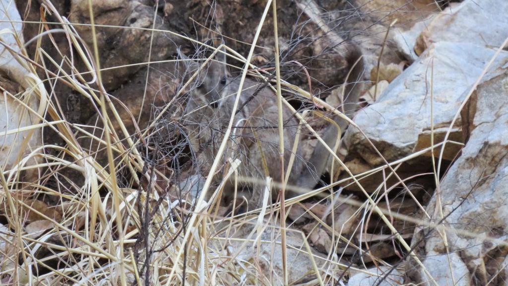 |
| Short-eared wallaby at Silent Grove |
Left Silent
Grove at 8:10 and wasted time going to Derby Aboriginal art gallery (same as in 2008
– only attractive paintings were over $2000 and too big for our home) and to
Derby Waste Water wetlands (same as in 2008 but just black ducks and white
ibis).
Decided to stay at
Roebuck Roadhouse as it was in between the roads to Port Headland and Broome
Bird Observatory.
We booked a 7:50am Mangrove
Tour at the Observatory, costing $70pp for 3 hours.. Had to drive 20 km towards Broome,
then 16km on a poor sand road. Steph, a
young Italian biologist volunteer, was enthusiastic and careful. The only people on the tour, we were kitted out
with mud shoes – very comfortable. A short drive in a 4WD vehicle was followed by a walk along a beach with
fringing grey mangroves towards Crab Creek.
There we were led on a muddy, slippery path through mangroves bordering
the creek until we could see the distant shoreline with many birds. Photography was difficult.
Not an exciting activity, but we're hard to please and Broome did not appeal in 2008, except for the Stairway to the Moon.
Stayed overnight at 80 Mile Beach, nice but just as windy as in 2008
and beach has warnings against swimming. Boring drive next day to BHP's
Port Hedland, where we had a horrible stay in 2008, so went on to Rio's
Karratha where we stayed 3 nights.
 |
| Wind surfer Karratha | | | |
 |
| Rocks typical of Karratha landscape, not spoil from mining |

 |
| Zebra finches |

This area had unexpected interesting features. Port Samson is a beachside town with a young population and a lively, attractive pub.
 |
Crested terns, Pt Samson
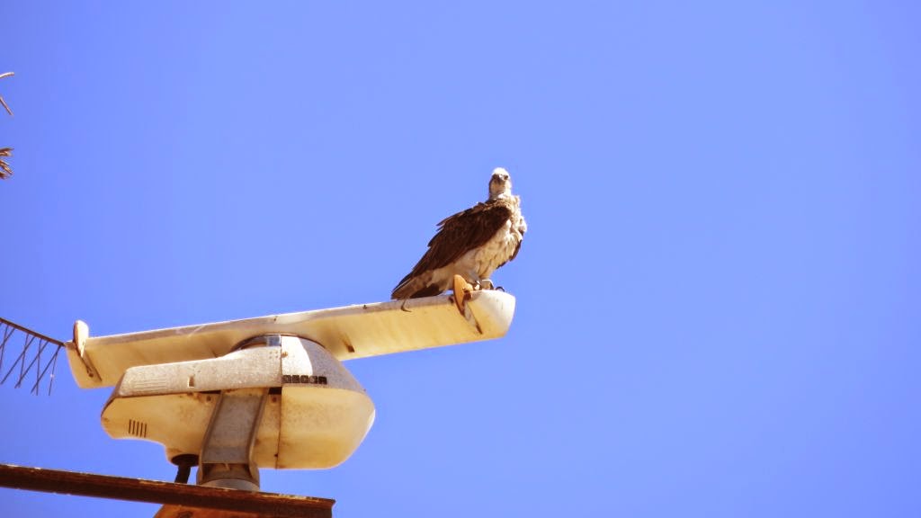 |
| One of several ospreys nesting in the area |
|
 |
| Rio shiploader seen from Pt Samson |
|
|
|

Roebourne has a tourist centre in an old gaol (built by Bunning Bros.!) which in the past has also been a courthouse and sobering-up centre. With summer temperatures up to 49 degrees, Roebourne was gazetted in 1866 and still has many historical buildings despite cyclones. We joined a bus tour from there to Rio's Dampier port complex and from there to Cossack for lunch.

The bond store (above) was a pleasant place for our lunch.
Cossack
once served as the port for Roebourne and was home to a fast growing
pearling industry. Thousands of people stayed there when seeking
fortune in the Pilbara gold rush. However, by 1904, shipping was
relocated to Port Samson, the pearling fleet had relocated to Broome and
the gold rush had diminished. Cossack was abandoned by the 1950's and
remained in ruins until 1979. Then restoration began and it is now a
museum town, quite attractive.
 |
| Gomphrena canescens at Cossack |
|
|
 |
| Cossack police station c 1890 |
|
|
 |
| This friendly guy greets visitors to Rio's port | |
|
|
 |
| Two wagons of ore are overturned together on to a conveyor belt at this point. Each train has 249 wagons; each wagon carries 100 tonnes. One of the conveyors is 55 km long. |
 |
| A shiploader wharf is on the left. Ten trainloads of ore go into the ship, using 9 hatches. It takes 24 hours to load one ship. The wharf is 3.3 km long. |
|
|
|
|
|
We finished the day at Karratha tourist centre with a 20 minute video of the Rio-owned road to Mt Tom Price, compulsory if you want to save time by using this road (318 km vs 573 on highways). A permit is then issued.
The Rio route was an excellent dirt road bordering Rio's rail line and we found the experience quite interesting. Huge vehicles occasionally appeared in an almost blinding cloud of dust, making the safety video a good idea. Photos below were from the road between Millstream and Tom Price.
En route to Tom Price, we stayed overnight at Millstream National Park. The campsite was well-kept but not appealing, but walks around the 1930's homestead were most attractive. The homestead is the visitor information centre for the park and was interesting in its own right.
 |
| 1930 painting by Doug Gordon, 12-year old son of the owner | |
1920’s pastoral station homestead
Spring-fed watercourses, shady, palms
everywhere. Next door was the pumping
station used by Rio – hope the groundwater can cope. 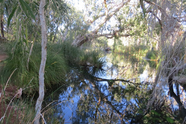
1920’s pastoral station homestead
 |
| Star finches were easy to find in the palms |
 |
| Paperbarks on Millstream walk | | | | | |
|
|
 |
| Swimming area on Fortesque River where we had lunch. Some hardy young men dived in, briefly! Very cold. |
On arrival at Tom Price, we sought advice on a crack which had appeared in our windscreen. It could not be repaired so David decided to hope it would be OK till we got home. (And it was!). Stayed at a nice caravan park there and shopped at the local Rio-subsidised Coles - cheaper than Brisbane with good fresh produce.
 |
| Tom Price corellas are pink from rolling in dirt. |
|
|
 |
| Ready for work |
|
 |
| 40 to 100 years of ore still to dig |
 |
| BIG dump truck | | | | |
|
|
 |
| BIG loader |
An easy drive from Tom Price to a favourite park, Karijini, where we had walked 4 gorges in 2008. The campsite adjoins Dales Gorge which I remembered as a steep walk up and down but not a problem. This time water levels were higher and some parts were dangerously slippery. Just as beautiful as before, 3 hours walking from Fortescue Falls to Circular Pool where David had a swim. Then a one km walk back along the Gorge Rim, easy except for steep steps up from the pool.
 |
| Starting the walk |
 |
| A long way down |
 |
| Lovely place for lunch |
 |
| Snappy gums are common in this area |
We finished our stay in Karajini with an easy 3km walk along Kalamina Gorge, which did not feature as an attraction in 2008. Very pretty but we took no pictures - looked much the same as the bottom of Dales Gorge but much easier to access.


No comments:
Post a Comment